

Veículos Terrestres
Caminhão Autônomo
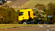
Projeto de colaboração entre LRM e a empresa Scania apresenta caminhão autônomo totalmente desenvolvido no Brasil. A plataforma utilizada utilizada nos dentro do campus da universidade conta com um sistema computacional que processa informações obtidas por sensores em tempo-real, permitindo uma navegação segura e eficiente.
[Mais informações] [Release oficial] [Fotos]
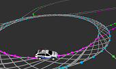
CaRINA 2 - Veículo Autônomo
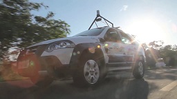
O CaRINA 2 é uma plataforma robótica utilizada no desenvolvimento de sistemas de percepção, controle e tomada de decisão para navegação autônoma e assistiva em ambientes urbanos. Ele conta com controle computacional de esterçamento, aceleração e freio, e diversos sensores como: GPS, IMU, câmeras e lasers.
[Mais informações] [Videos & Fotos]
[Artigos relacionados: ITSC2016]
Framework de Simulação para Veículos e Direção Assistiva
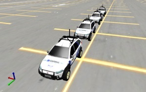
A simulação é uma ferramenta fundamental para o desenvolvimento de software para robôs e veículos inteligentes. Além de diminuir o tempo de desenvolvimento e a logística, a simulação permite o teste de dispositivos nem sempre dispoíveis fisicamente. Esse projeto propõe o desenvolvimento de um sistema de simulação para múltiplos veículos em diversos tipos de ambientes, e a simulação de rede de comunicação entre eles. O sistema em desenvolvimento também permite o controle manual de veículos simulados em tempo real, permitindo também o desenvolvimento de aplicações de assistência ao condutor.
[Artigos relacionados: ITSC2014 ITSC2016]
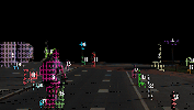
Detecção de Obstáculos e Vias
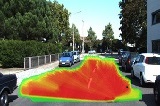
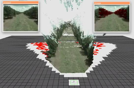
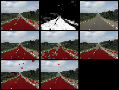
Esse trabalho propõe o desenvolvimento de algoritmos para a detecção de obstáculos e de vias navegáveis em ambientes urbanos a partir de nuves de pontos. Nuves de pontos são criadas por diversos tipos de sensores como câmeras estéreo, sensores laser (LIDAR 3D), e sensores indoor, como o Kinect. A meta é o desenvolvimento de algoritmos precisos, robustos e eficientes computacionalmente que possam ser aplicados a diversos dispositivos de percepção.
[Artigos relacionados: IV2013 IV2014 ITSC2014 IROS2015(W) ROB2017]
Road Detection Using Deep Learning
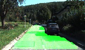
Road detection is a crucial task in autonomous navigation systems. It is responsible for delimiting the road area and hence the free and valid space for maneuvers. In this work, we consider the visual road detection problem where, given an image, the objective is to classify every of its pixels into road or non-road. We address this task by proposing a convolutional neural network architecture. We are especially interested in a model that takes advantage of a large contextual window while maintaining a fast inference. We achieve this by using a Network-in-Network (NiN) architecture and by converting the model into a fully convolutional network after training.
[Related papers: ICRA2016]
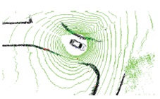
Obstacle Detection and Segmentation
Obstacle Detection is a fundamental problem in autonomous navigation. This work addresses the segmentation of general obstacles using stereo vision with no need of dense disparity maps or assumptions about the scenario. A sparse set of points are selected based on a local spatial condition. These points are then clusterized based on the disparity values and its neighborhood.
[Related papers: IROS2015(W)]
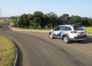
Curb and road marking detection for vehicle localization
A correct perception of the traffic elements is required for autonomous cars to follow the traffic codes. Curb and road marking are necessary to keep the cars in the streets and in the correct lanes. These features can also be mapped and used vehicle's localization estimation.
[Videos] [More Info] [Download Available]
[Artigos relacionados: IV2014 ITSC2014 T-ITS2016]
Controle de Veículos Autônomos
O controle preciso e robusto é um das principais requisitos de um veículo autônomo, especialmente em ambientes urbanos onde é necessário se manter dentro de faixas de trânsito a maior parte do tempo. Esse projeto propõe o desenvolvimento de técnicas de controle para veículos autônomos, especiamente em situações de limite da estabilidade.
[Artigos relacionados: IV2014 ITSC2014 ITSC2016]
Automatic Mapping of Urban Environments
Road network maps are highly used for autonomous vehicle path planning. This work proposes a novel method for automatic construction of road network maps. Collected GPS points are stored into flexible waypoint data structures that can represent relevant information for vehicle navigation. The mapping method also reduces the amount of waypoints by identifying and converting them into lane structures.
[Related papers: LARS2014]
Veículos Aéreos (UAVs)
Detection of Eucalyptus Deceases from Aerial Images
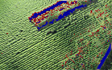
One of the challenges in precision agriculture is the detection of diseased crops in agricultural environments. This work (in cooperation with LSEC Lab) proposes a methodology to detect the diseases in Eucalyptus crops. An unmanned aerial vehicle is used to obtain high-resolution RGB images of a predefined area. The methodology enables the extraction of visual features from image regions and uses several supervised machine learning (ML) techniques to classify regions into three classes: ground, healthy and diseased plants.
[Related papers: ICRA2015]
Path Planning Under Uncertainty for UAVs
Airborne monitoring in agriculture can a substantially impacts on the identification of diseases and produce accurate information on affected areas. The problem can be formulated as a classification task on aerial images with significant opportunities to impact other fields. This work proposes an active learning method through route planning for improvements in the knowledge on visited areas and minimization uncertainties about the classification of diseases in crops. Binary Logistic Regression and Gaussian Process are used for the detection of pathologies and map interpolation, respectively. A Bayesian optimization strategy is also proposed for the planning of an informative trajectory, which results in a maximized search for affected areas in an initially unknown environment.
[Related papers: ICRA2016]
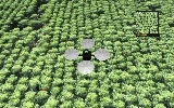
Tree Counting and Segmentation from Aerial Images
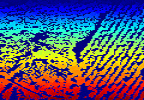
An individual tree crown analysis from aerial images can provide an improvement in economic planning and management of planted forests, as well as identifying diseases on individual trees. To achieve an automated individual tree crown detection, the use of segmentation techniques from image processing becomes a requisite. This work deals on the segmentation and counting of Eucalyptus crops using Near-infrared (NIR) images obtained by UAVs. The proposed methodology employs removing soil using machine learning techniques and then uses segmentation methods from image processing to delineate individual tree crowns.
Projetos Encerrados
Obstacle Detection and Classification in Agricultural Environments
Automation of agriculture machines may reduce human errors, avoid direct human contact to pesticides, and improve efficiency. One of the main challenges of the agricultural machinery automation is a reliable real time obstacle detection system. We propose a robust obstacle detection system that can deal with several types of static and dynamic obstacles and it is also able to distinguish among tall grass, bushes, small animals and people.
[Related papers: ITSC2013]
Road area detection using artificial neural networks
In order to execute autonomous driving in outdoor urban environments it is necessary to identify parts of the terrain that can be traversed and parts that should be avoided. This work describes an analyses of terrain identification based on different visual information using a MLP artificial neural network and combining responses of many classifiers. Experimental tests using a vehicle and a video camera have been conducted in real scenarios to evaluate the proposed approach
[More info] [Download Available]
[Related papers: JIRS2011 IV2012]